

TEMPO.CO, Jakarta - The Indonesian Meteorology, Climatology, and Geophysics Agency (BMKG) has announced several areas under tsunami alert and warning status following a 7.6 magnitude earthquake that struck the Ternate region, North Maluku, on Thursday, April 2, 2026. Based on expert analysis, the earthquake is categorized as having the potential to trigger a tsunami.
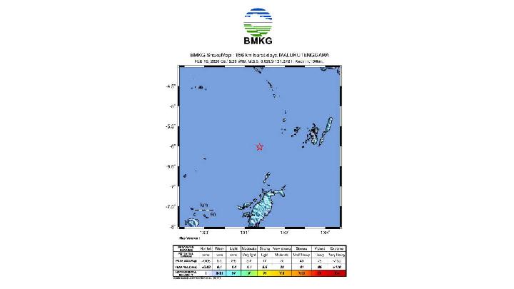
Acting Director of Earthquake and Tsunami at BMKG, Rahmat Triyono, stated that the earthquake was of tectonic type with an epicenter located at the coordinates 1.25 degrees North Latitude and 126.27 degrees East Longitude, precisely located at sea, 129 kilometers southeast of Bitung, North Sulawesi, at a depth of 33 kilometers.
"The earthquake that occurred is a type of shallow earthquake due to the deformation activity of the earth's crust. The results of the source mechanism analysis indicate that the earthquake has an upward movement mechanism," Rahmat said in a written statement after the incident.
Based on BMKG's modeling results, the following are the areas with alert and warning statuses for tsunami due to this earthquake:
Alert Status
- Ternate City
- Halmahera
- Tidore City
- Bitung City
- South Minahasa
- South South Minahasa
- South North Minahasa
Warning Status
- Sangihe Islands
- North Minahasa North
- South Bolaangmongondow
Based on seawater level monitoring by Tide Gauge, a tsunami has been detected in West Halmahera at 06:08 WIB (Western Indonesian Time) with a height of 0.30 meters, Bitung at 06:15 WIB with a height of 0.20 meters, Sidangoli at 06:16 WIB with a height of 0.35 meters, North Minahasa at 06:18 WIB with a height of 0.75 meters, and Belang at 06:36 WIB with a height of 0.68 meters. Then, until 06:50 WIB, BMKG's monitoring results show 11 aftershock earthquake activities with the largest magnitude of M5.5.
Read: Powerful Earthquake Strikes Molucca Sea Near Indonesia
Click here to get the latest news updates from Tempo on Google News
Powerful Earthquake Strikes Molucca Sea Near Indonesia
2 jam lalu

A major 7.4-magnitude earthquake has jolted eastern Indonesia, triggering fears of a tsunami. But the initial warning has now been lifted.
Powerful 7.6-Magnitude Earthquake Rocks Ternate, Triggers Tsunami Alert
4 jam lalu

An earthquake with a magnitude of 7.6 on the Richter scale struck Ternate, North Maluku, on Thursday, April 2, 2026, at around 07:48 WIT, causing panic and people fleeing from their homes.
M5.3 Quake Off Sukabumi Felt Across West Java, No Tsunami Risk
20 hari lalu
The earthquake off Sukabumi, West Java, was caused by the subduction of the Indo-Australian Plate beneath the Eurasian Plate.
Magnitude 5.5 Earthquake Hits Indonesia's Maluku, No Tsunami Risk
43 hari lalu
The earthquake was classified as moderate and was caused by rock deformation within the Banda Sea Plate.
M6.2 Megathrust Earthquake in East Java, BMKG Reports No Tsunami Threat
55 hari lalu
The earthquake that occurred is a type of shallow earthquake due to subduction plate activity.
Fact Check: Claim of US Nuclear Test Behind 2004 Aceh Tsunami Is False
18 Januari 2026

Fact check - All claims in the circulating narrative are refuted by facts from credible sources.
BMKG: Strong 7.1 Earthquake Jolts North Sulawesi, No Tsunami Risk
11 Januari 2026
BMKG detected a 7.1 magnitude earthquake in Melonguane, North Talaud Islands, North Sulawesi on Saturday, January 10, 2026 evening.
Geological Agency: Indonesia Saw 41 Destructive Earthquakes in 2025
7 Januari 2026
Most of the destructive earthquake events are caused by active faults located on land.
Aceh's Bitter Lesson, Relearned
28 Desember 2025
In 2004, Aceh was hardest hit by the Indian Ocean tsunami. In 2025, Indonesia's most disaster-aware province was among the worst hit by floods
Fact Check: Misleading Claim Says Australia Demanded Return of Aceh Tsunami Aid
28 Desember 2025

Fact check - To date, the Australian government has never asked for the earthquake and tsunami aid to be returned.