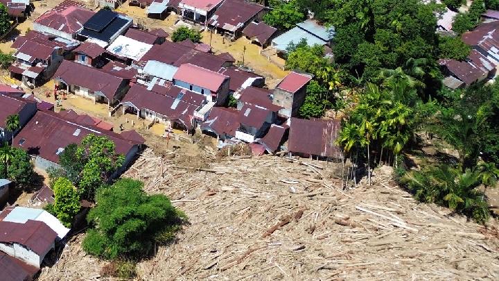
TEMPO.CO, Jakarta - The occurrence of coastal flooding, amplified by sea level rise (SLR), is becoming increasingly severe worldwide. In Jakarta, for instance, sea levels in coastal areas already exceed land elevation, requiring concrete embankments to prevent widespread flooding, a reality underscored by recent viral videos showing water seeping into elite residential areas and inundating roads in the Ancol area.
The Director of Maritime Meteorology at BMKG, Eko Prasetyo, confirmed that the primary trigger for this high and extensive sea level rise is the shortened distance between the Earth and the Moon, specifically when the Moon reaches its closest point (perigee). "The maximum sea level will increase in several locations during perigee," he stated.
The recent impact of the year's second-largest supermoon, which occurred in the first week of December, is still being felt across many Indonesian coastal areas. The sea is not only breaching embankments but also intruding inland by flooding river systems.
Land Subsidence
However, the Indonesian Environmental Forum (Walhi) warns that land subsidence, as acutely seen in Jakarta, plays a far more significant role in coastal flooding. Land subsidence is triggered by spatial exploitation, unplanned urban development, and unchecked massive groundwater extraction.
A recent report published last November by the World Economic Forum (WEF) highlighted the lowering of urban land elevation as a global challenge that has not received sufficient attention. The report, titled 'Resilient Economies: Strategies for Sinking Cities and Flood Risks,' warned that land subsidence "can threaten the well-being and livelihoods of cities worldwide."
The 49-page report explained that land subsidence is primarily caused by unsustainable human behavior, ranging from groundwater extraction to rapid urbanization. This pressure drastically increases the risk of flooding, infrastructure damage, and population displacement.
"When combined with rising sea levels and extreme weather, land subsidence can transform manageable risks into existential threats to businesses, governments, and society," according to the WEF.
The scale of sinking cities is massive. Globally, approximately 6.3 million square kilometers of land—equivalent to the combined area of India, Argentina, and Japan—are estimated to experience land subsidence. This condition affects an estimated two billion people worldwide.
This issue is further exacerbated by the accelerated rise in sea level. In the last three decades, the rate of global sea level rise has more than doubled to around 3.3 millimeters per year. Projections indicate that the sea level could rise by up to 16.9 centimeters in the next 30 years. In several coastal cities, however, the rate of land subsidence even surpasses the rate of sea level rise, further increasing the risk of flooding and damage.
Sinking Cities: Indonesia and Global Hotspots
The WEF report notes that land subsidence is not evenly distributed. An analysis of 99 coastal cities, using data from 2015 and 2020, showed that 33 of them experienced land subsidence at a rate up to five times faster than the global sea level rise. While Shanghai, for example, has areas subsiding at a rate of up to 10 millimeters per year, the fastest rates are predominantly found in South Asian, Southeast Asian, and East Asian cities.
In extreme cases, specific areas in a city experience subsidence 10 to 20 times faster than the rise in sea level. This was recorded in cities such as Tianjin, Semarang, and Jakarta.
The northwest coast of Jakarta reported a shocking rate of land subsidence of up to 280 millimeters, or almost 0.3 meters, per year. Meanwhile, Semarang experienced subsidence of around 60–120 millimeters per year.
The sinking city phenomenon is not only happening in Asia. In the United States, high-resolution satellite data from 2015 to 2021 shows that around 20 percent of urban areas in 28 major cities experienced land subsidence, potentially affecting approximately 34 million people, or 12 percent of the national population. Cities like Houston, Dallas, Fort Worth, Chicago, New York, and Detroit recorded over 70 percent of their areas being affected. Since 2000, over 90 flood events have occurred in eight U.S. cities with subsidence rates exceeding 3 millimeters per year, placing around 29,000 buildings at high risk.
Several other global cities also recorded significant figures. According to the data presented by the WEF, Mexico City experienced a land subsidence of around 350-450 millimeters per year, making it one of the most severely affected cities in the world. The San Joaquin Valley in the United States recorded a subsidence of about 150-300 millimeters per year.
In Iran, the Rafsanjan Plain experienced a subsidence of up to 300 millimeters per year, while Tehran's rates varied from 50-250 millimeters per year. Other cities, including Ho Chi Minh City (40-70 millimeters per year), Bangkok (9-30 millimeters per year), Lagos (2-87 millimeters per year), Yangon (10-110 millimeters per year), and Beijing (15-138.5 millimeters per year), are also included in the list of affected areas.
Read: Indonesia Issues Weather Warnings as Cyclone Bakung Forms in Indian Ocean
Click here to get the latest news updates from Tempo on Google News